UAV for Disaster Mitigation & Management: Designing a Thermal Camera-Equipped Drone for Human Body Detection
Introduction:
Monitoring and managing disasters is a critical aspect of safeguarding both the environment and human populations. Unmanned Aerial Vehicles (UAVs) equipped with advanced camera sensors have emerged as powerful tools for disaster mitigation. This project focuses on designing and assembling a drone specifically tailored for human body detection as part of comprehensive disaster management. The key feature of this UAV is its payload, a thermal camera, which allows for accurate temperature measurements and aerial video streaming.
Objective:
The primary objective of this project is to develop a drone capable of human body detection using a thermal camera, contributing to enhanced disaster mitigation and management efforts. The utilization of cutting-edge technologies ensures precise and real-time data collection.
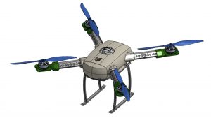
Hardware Specifications:
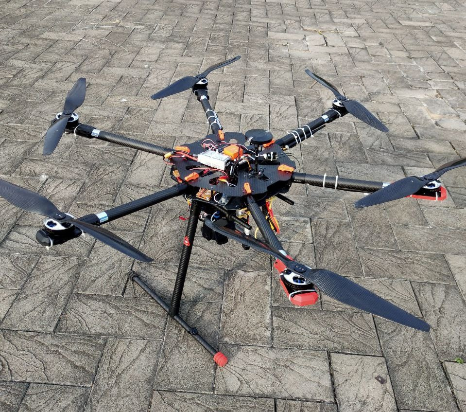
- Frame: Tarot X6
- Wheelbase: 690 mm
- Motor: 340 KV
- Propeller: 18 inches
- ESC: 40A, 6S
- Battery Capacity: 22,000 mAh , 6S
- All-up Weight: 6.5 kg
- Payload Weight (Camera): 112.5 g
- Thermal Camera: Flir Vue Pro R
- Camera Resolution: 24.3 MP
- Flight Time: 20 minutes
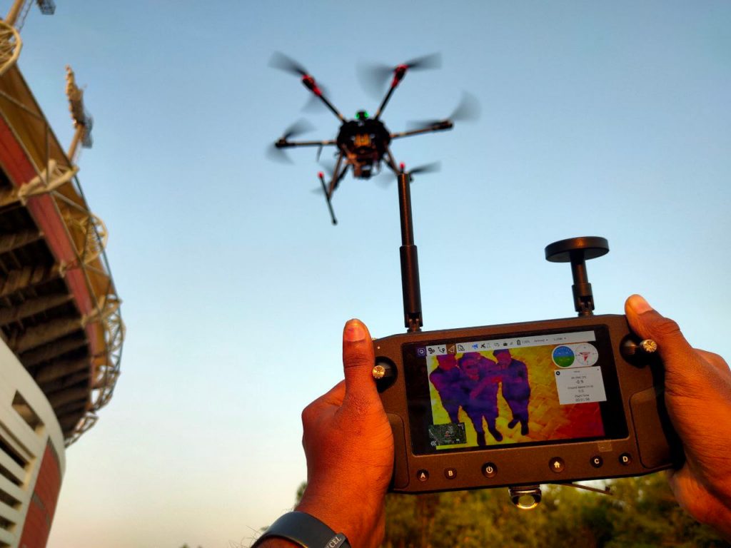
Camera and Streaming Technology: The project utilizes a thermal camera, specifically the Flir Vue Pro R, for capturing aerial videos. This camera provides drone operators with the ability to obtain accurate non-contact temperature measurements from an aerial perspective. The micro HDMI port on camera seamlessly integrates with the drone's Air Unit system, offering video streaming .
Gimbal Design: A custom-designed gimbal is incorporated into the drone to securely mount the thermal camera. This gimbal ensures stable and controlled movements, enabling the camera to capture clear and steady footage during flight.
Communication System: The communication system relies on the MAVLink protocol for seamless connectivity. The Herelink transmitter serves as a remote controller, ground station, and wireless digital transmission system. It is designed for use with the Cube Autopilot, Ardupilot, or PX4 flight controllers. The transmitter facilitates video streaming, and the streamed video is transmitted to a laptop via the Herelink transmitter hotspot.
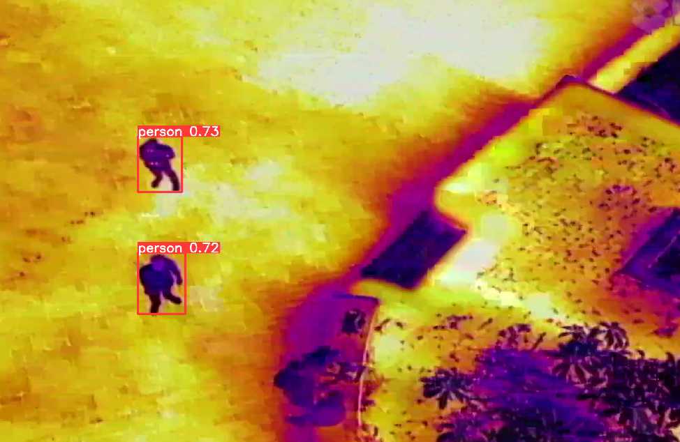
Object Detection and Data Analysis: The YOLOv5 (You Only Look Once) object detection model is implemented to identify human subjects in the streaming video. Once a person is identified, the system saves the location of the drone or person as a file. This real-time analysis enhances the effectiveness of disaster response by providing immediate information about the location of individuals in need.
Software Utilized:
- Mission Planner
- Q Ground Control
- YOLOv5 Object Detection Algorithm
Conclusion:
This project represents a significant step forward in leveraging UAV technology for disaster mitigation and management. The integration of a thermal camera, custom gimbal design, and advanced object detection algorithms enhances the drone's capabilities for identifying human subjects in disaster-stricken areas. The combination of hardware and software components ensures efficient data collection and real-time analysis, contributing to more effective disaster response efforts.
What i don't understood is in fact how you are not actually a lot more neatly-preferred than you might be now. You are very intelligent. You know thus significantly on the subject of this matter, produced me personally consider it from a lot of numerous angles. Its like women and men are not involved until it¦s something to accomplish with Girl gaga! Your personal stuffs outstanding. Always deal with it up!